11 Epic Mountain Drives in India – Perfect Summer Road Trips
Revelation
March 17, 2026
Posted By : Admin
11 Epic Mountain Drives in India – Perfect Summer Road Trips
Hit the road this summer with 11 epic mountain drives across India. From the winding Himalayan passes to serene Western Ghats, these routes promise breathtaking views, cool escapes, and unforgettable adventures. Perfect for road trip lovers, families, and thrill-seekers, each drive blends natural beauty, cultural charm, and refreshing summer vibes. Discover hidden gems, panoramic landscapes, and the joy of driving through India’s most scenic mountain routes.
India Road Trips · Himalayan Drives · Summer 2026
11 Epic Mountain Drives in India Perfect for Summer
Eight roads that remind you why the journey matters more than the destination — from the world's highest motorable passes to river gorges carved by glaciers over a million years.
India has more high-altitude roads than almost any country on earth. The collision of the Indian subcontinent with the Eurasian plate — still ongoing, still pushing the Himalayas skyward at a measurable rate per year — has produced a mountain frontier 2,500 km long and up to 700 km deep, threaded by rivers that carved valleys before the mountains rose around them, and now by roads that human persistence has forced through terrain that seems designed specifically to prevent them. The best of these roads are, simply, among the most magnificent driving experiences available anywhere on the planet.
Summer — specifically the window from late May through September — is when India's greatest mountain roads are open, passable, and at their most beautiful. The snows have melted enough to reveal the high passes; the monsoon, which arrives in the north-west only partially or not at all, keeps the air clear and the rivers dramatic without making the roads impassable. This guide covers the eight drives that best reward the time and effort required to reach them — rated by the quality and variety of the experience, not merely by altitude or danger. Whether you are planning a self-drive expedition or a fully supported India mountain tour, these are the eleven roads every serious road traveller in India needs on their list — spanning the Himalayas, the Western Ghats, the Kumaon ranges, and the cloud-forests of the North-East.
The 11 Greatest Mountain Drives in India for Summer
Each drive below is profiled with its total distance, the key passes it crosses, the recommended vehicle type, the difficulty level, the ideal summer window, and the specific quality of experience that distinguishes it from every other mountain road in India.
01
Himachal Pradesh → Ladakh
Manali to Leh Highway (NH-3)
The Ultimate Indian Mountain Drive — Five Passes, Two Days, One Lifetime
478 km total5 high passesMax alt: 5,328 m (Tanglang La)Open: Late May – Oct2 days minimum
There is no road in India — and arguably no road in Asia — that delivers the quantity and variety of awe packed into the 478 km of the Manali to Leh Highway. Beginning in the Kullu Valley at 2,050 metres above sea level, it ends in the capital of Ladakh at 3,524 metres — but between those two points it climbs and descends across five of the highest motorable mountain passes on earth, through landscapes that change with a frequency and drama that most road trips spread over an entire country's worth of distance. This drive is the reason that motorcycle rallies, road-trip films, and bucket-list travel journalism exist in India.
The Manali–Leh Highway (NH-3) — one of the world's great road journeys, crossing five high passes from lush Kullu Valley to the barren Trans-Himalayan plateau of Ladakh. Baralacha La (4,890 m) lies 400 km ahead. Image: tourpackages.asia | revelationholidays.in
The drive is logistically structured across two days with an overnight stop at either Jispa (4,200 m), Sarchu (4,290 m), or Pang (4,500 m) — tent camps that operate from June through September and are as exposed and atmospheric as any accommodation in India. Day One takes you from Manali through the Atal Tunnel (which since 2020 bypasses the notorious Rohtang Pass completely, opening the first 51 km year-round and saving the most difficult section of the old road), across Baralacha La at 4,890 metres, and down to the camp. Day Two crosses Nakee La (4,739 m), Lachulung La (5,059 m) — frequently the snowiest pass of the five — and the long approach to Tanglang La at 5,328 metres, the second-highest motorable road in the world, before the extraordinary descent into the Indus Valley and the final run into Leh.
What makes this drive irreplaceable is the speed of the landscape transformation. In the space of Day One, you drive from deciduous temperate forest (pine, oak, birch) through alpine meadows carpeted in June with blue poppy and wild strawberry, into the stark, colourless world above the tree line where only the brightest-flowered cushion plants survive, and finally into the lunar landscape of the Lahaul plateau where the only colour is the blue of the sky and the occasional flash of turquoise in a glacial stream. Day Two intensifies this: the Morey Plains — a vast, flat, arid plateau at 4,500 metres between Pang and Lachulung La — are one of the most disorienting driving environments in India, a place where the horizon appears to be at eye level and the road vanishes into a mirage of heat shimmer at midday. The final hour of descent into Leh, when the Indus Valley suddenly widens and the ancient city appears against a backdrop of red-brown mountains with Stok Kangri gleaming white above — is one of the great arrival experiences in Indian travel. Book our Ladakh 6-day tour package or explore the Ladakh spiritual travel guide for further reading. Also available via Revelation Holidays Ladakh.
Distance
478 km
Highest Pass
Tanglang La 5,328 m
Best Months
June–September
Vehicle
4WD SUV essential
States
Himachal Pradesh, Ladakh
02
Jammu & Kashmir → Ladakh
Srinagar to Leh via Zoji La (NH-1)
The Ancient Silk Road — From Kashmir's Green Valley to Ladakh's Moon Landscape
424 km totalZoji La: 3,528 mDrass, Kargil, LamayuruOpen: April – November1 day to 2 days
The Srinagar to Leh highway — historically the only land route connecting Ladakh to the rest of India before the Manali–Leh road was constructed — is the older, more historically layered, and in many respects more atmospheric of the two great Ladakh drives. At 424 km, it is shorter than the Manali–Leh route but crosses fewer high passes — the critical one being Zoji La at 3,528 metres, a narrow, often treacherous 9-km section of road that is the gateway between the Kashmir Valley and the Drass Valley and represents one of the steepest and most dramatic terrain changes on any road in India. On one side of Zoji La: green, forested, cloud-covered Kashmir valley. On the other: the grey-brown rocky moonscape of Ladakh. You drive through it in 20 minutes and arrive in an entirely different geological and climatic zone.
The drive begins in Srinagar — making it easy to combine with a Dal Lake houseboat stay — and passes through Sonamarg (the Meadow of Gold, at 2,800 m) before the Zoji La crossing. Drass, 160 km from Srinagar, is the second-coldest inhabited place in Asia and the site of the 1999 Kargil War; the Drass War Memorial and the visible shrapnel scars on the rock faces above the town add a layer of recent historical gravity unusual in mountain travel. Kargil at 2,676 metres is the overnight stop on the standard two-day itinerary — a frontier town with a distinctive Central Asian atmosphere, flat-roofed, dusty, and quietly charismatic. The drive from Kargil to Leh, passing through the extraordinary Buddhist landscape of Lamayuru (home to Ladakh's oldest monastery, set dramatically in a landscape of eroded lunar badlands), the Indus River gorge at Nimmu, and the approach to Leh through the ancient palace town of Basgo, constitutes some of the finest single-day driving in India.
The Srinagar–Leh highway (NH-1) on the approach to Leh — Leh town and the ancient palace are visible in the valley below. This ancient Silk Road crosses Zoji La, Drass, Kargil and Lamayuru before reaching the Indus Valley. Image: tourpackages.asia | revelationholidays.in
Distance
424 km
Key Pass
Zoji La 3,528 m
Best Months
May–November
Vehicle
4WD strongly recommended
States
J&K, Ladakh
03
Himachal Pradesh — High Desert Plateau
Spiti Valley Circuit — Shimla to Manali via Kaza
The Middle Land — Where the Himalayas Become the Tibetan Plateau
~460 km circuitKunzum La: 4,551 mKaza 3,800 m baseOpen: June – Oct (summer route)3–5 days minimum
The Spiti Valley circuit is, for a significant number of experienced India road travellers, the finest drive in the country — not because it is the most dramatic or the highest (though it is both), but because it is the most sustained in its beauty and the most remote in its character. The circuit typically runs as a loop: Shimla east along the Sutlej Valley through Kinnaur to Nako and Tabo, then north over Shingo La or via the Sumdo junction into Spiti proper and the district headquarters at Kaza (3,800 m), then west and north over Kunzum La (4,551 m) to Manali — or in reverse. The complete loop covers roughly 460 km and takes a minimum of 3 to 5 days to do justice to.
The Shimla–Spiti Valley drive — where lush Himalayan forest meets the stark Tibetan-plateau landscape of Spiti. Key Monastery (right) perches on a volcanic plug at 4,166 m above the Spiti River. Image: tourpackages.asia | revelationholidays.in
The character of the Spiti drive is unlike any other in India. The landscape is defined by the colours of exposed geology — the burnt orange of iron-oxide sandstone, the white of limestone, the black of basalt, the grey-blue of shale — in a treeless, almost water-free environment where the only signs of human life are the occasional stupa on a ridge, the whitewashed cube of a farmhouse in a valley bottom, and the extraordinary monasteries at Key (Ki Gompa), perched on a volcanic plug above the valley at 4,166 metres and considered one of the most striking religious buildings in the Himalayas. The fossil beds of Langza — a small village above Kaza where Jurassic marine fossils erode out of the hillside — remind you that this entire plateau was once ocean floor. Chandratal Lake (4,300 m), a high-altitude crescent-shaped lake accessible via a 2 km walk from the road above Kunzum La, is one of India's most beautiful natural sites and a reliable overnight camping destination in July–August. The Spiti circuit is served by our Himachal Pradesh mountain packages.
Circuit Length
~460 km
Key Pass
Kunzum La 4,551 m
Best Months
June–October
Vehicle
4WD/high clearance essential
Permit
Inner Line Permit required
04
Arunachal Pradesh — Eastern Himalayas
Tezpur to Tawang via Sela Pass (NH-13)
The Far East Himalaya — Buddhist Monasteries Above the Clouds
~320 km Tezpur to TawangSela Pass: 4,170 mTawang: 3,048 mOpen: April – NovemberInner Line Permit required
The drive from Tezpur in Assam to Tawang in Arunachal Pradesh is India's most underappreciated great mountain road — a 320 km journey through a landscape of escalating drama that begins in the humid subtropical plains of Assam and ends at one of Asia's most important and most beautifully situated Tibetan Buddhist monasteries. The road climbs from near sea level to over 4,000 metres through a compressed sequence of ecological zones that in the Himalayas would take weeks of walking — from tea estates and bamboo jungle to dense broadleaf forest, from rhododendron thickets to bare alpine meadow, in the space of a single day's driving.
The critical section is the approach to and crossing of Sela Pass at 4,170 metres — a broad, lake-studded plateau above the tree line that is frequently shrouded in cloud and often carries snow into June. The Sela Lake beside the pass, fed by springs and frozen for much of the year, reflects the sky with a precision that blurs the boundary between water and atmosphere. The descent from Sela on the Tawang side reveals the Tawang Valley in stages — first a glimpse of the massive white monastery complex on the hillside above the town, then the full panorama as the road swings round a final buttress. Tawang Monastery, founded in 1681 and one of the largest in the world outside Tibet, is the destination that the entire 320-km drive has been building toward — a living Buddhist institution at 3,048 metres, surrounded by mountains that push into the Tibetan plateau. The Bumla Pass (4,563 m) on the India-China border, 35 km above Tawang, is accessible to Indians with permits and is one of the highest driveable points in the eastern Himalayas. See all India mountain packages including North-East India circuits.
Distance
~320 km (Tezpur to Tawang)
Key Pass
Sela Pass 4,170 m
Best Months
May–October
Vehicle
4WD essential, especially in rain
Permit
ILP mandatory for all non-residents
Drive the Himalayas with Expert Support
From Manali–Leh highway permits to Spiti Valley deep circuits — our mountain travel specialists handle every logistic so you can focus entirely on the road ahead.
Shimla to Chitkul via Kinnaur (NH-5 / Old Hindustan Tibet Road)
The Apple Country Highway — Carved Cliffs, Kinner Kailash and India's Last Village
~235 km Shimla to ChitkulChitkul: 3,450 mSangla Valley, KalpaOpen: All year to Kalpa; June–Oct to Chitkul2–3 days recommended
The Shimla to Kinnaur road — the old Hindustan–Tibet Road that once carried trade between the British Raj and Lhasa — is one of India's most nerve-wracking and most rewarding drives. For the first 130 km from Shimla through Rampur to Spillow, it follows the Sutlej River gorge through a dramatically narrowing canyon where, at several points, the road has been blasted directly into overhanging cliffs. The cliff-carving sections — particularly the notorious Tranda Dhank stretch near Wangtu, where the road is essentially a ledge on a vertical rockface above the roiling river — are the reason that every vehicle that has driven this road carries a dent from a falling stone and a story to accompany it. The drive demands full attention at all times and rewards that attention with scenery of a quality — a quality defined specifically by the interplay of vertical cliff face, white river, deep blue sky, and the bright orange of marigold fields in the valley floor — that is available nowhere else in Himachal.
Sangla Valley at 2,680 metres is the largest side valley in Kinnaur and the point where the drive transforms from a nerve-steadying gorge journey into something pastoral and extraordinarily beautiful: the flat valley floor is planted with apple orchards, pea fields, and buckwheat, the surrounding mountains rise to 6,000 metres on both sides, and the village of Sangla itself has a distinctive Kinnauri architecture of stone, wood, and slate that is quite different from the rest of Himachal. The drive ends at Chitkul at 3,450 metres — the last inhabited village on the India–China border in the Baspa Valley, and officially the last point in India that Indian nationals can reach by road without special permits. Standing at the chowk in Chitkul, looking up at the glaciated peaks of the Baspa watershed, knowing there is nothing between you and Tibet except ice and altitude, is an experience of frontier geography that is irreplaceable. Our Himachal mountain circuit can be extended to include the Kinnaur section.
Distance
~235 km (Shimla–Chitkul)
Highest Point
Chitkul 3,450 m
Best Months
May–October
Vehicle
Any car; 4WD beyond Sangla
State
Himachal Pradesh
06
Sikkim — Eastern Himalaya
Gangtok to Nathu La & Tsomgo Lake, Sikkim
The Dragon's Gate — India–China Border Drive Through Cloud Forest
54 km Gangtok to Nathu LaNathu La: 4,310 mTsomgo Lake: 3,753 mPermit requiredDay trip from Gangtok
The drive from Gangtok to Nathu La — the mountain pass on the India–China border that was one of the most important nodes on the historic Silk Road — covers just 54 km but climbs from 1,650 metres to 4,310 metres in that distance, passing through one of the most ecologically diverse vertical gradients in the Himalayan mountain system. The road begins in the warm, subtropical, prayer-flag-draped lanes of Gangtok, climbs through mist forest thick with rhododendron and magnolia, breaks through the cloud base into a high-altitude landscape of glacial lakes and rolling alpine meadow, and ends at the border marker where Indian and Chinese soldiers perform a ceremonial handshake at 4,310 metres. It is simultaneously one of India's shortest great mountain drives and one of the most condensed in its ecological and geographical drama.
Tsomgo Lake (Changu Lake) at 3,753 metres — a glacially fed high-altitude lake about 40 km from Gangtok — is the centrepiece of the drive for most visitors: a dark, intensely still body of water surrounded by steep hillsides that carry snow through June, with yaks grazing at the shoreline and, in October–November, the Brahmin ducks that migrate here from Tibet. The lake is at its most beautiful in October when the surrounding hillsides carry the full autumn colour of Sikkim's high-altitude scrub. The remaining 14 km to Nathu La beyond Tsomgo climb through bare, windswept terrain to the pass itself — now developed as a military tourism site with viewing platforms and a small market. Nathu La was reopened for bilateral trade in 2006 after 44 years of closure following the 1962 war, and the sense of history — and the surreal experience of looking across a 10-metre gap into China while standing in India — is unique to this drive. See North-East India packages including Sikkim circuits.
The Gangtok–Nathu La drive climbing 2,660 m in 54 km through Sikkim's cloud forest to the India–China boundary at 4,310 m. Prayer flags, snow peaks and a panoramic view of Gangtok town reward the ascent. Image: tourpackages.asia | revelationholidays.in
Distance
54 km (day trip)
Highest Point
Nathu La 4,310 m
Best Months
May–June, Oct–Nov
Vehicle
Any; shared jeeps available
Permit
Nathu La permit from Gangtok
07
Ladakh — The Most Remote Valley in India
Kargil to Padum — Zanskar Valley Drive
The Road to India's Most Isolated Valley — Gorge Driving at Its Most Extreme
240 km Kargil to PadumPensi La: 4,401 mZanskar River GorgeOpen: June – October2 days minimum
The Zanskar Valley is the most geographically isolated permanently inhabited valley in India — a high-altitude trans-Himalayan plateau completely enclosed by mountain ranges over 6,000 metres, accessible only by a single road (open from June to October) or, in winter, by the famous Chadar trek across the frozen surface of the Zanskar River. The 240 km drive from Kargil to Padum (the administrative centre of Zanskar) is one of the most demanding and most rewarding in Ladakh — a road that follows the Suru Valley and Zanskar River gorge through terrain of biblical severity, with monastery and village appearing at intervals that feel miraculous given the apparent impossibility of sustained human life in these conditions.
The drive begins easily enough through the green Suru Valley — where the Nun (7,135 m) and Kun (7,077 m) peaks provide a backdrop of glaciated mountain grandeur unusual in Ladakh — before crossing Pensi La (4,401 m), the access point to the Zanskar plateau. The Drang-Drung Glacier, visible from the pass as a river of compressed blue-white ice pouring down from the Pensi La snowfield, is one of the largest glaciers in the Indian Himalayan region and provides one of the most dramatic views from any Indian mountain road. Beyond Pensi La, the road descends into the Zanskar Valley proper — a wide, arid, U-shaped glacial valley at 3,500–3,800 metres — where the Sani Monastery (the only monastery in Ladakh on flat valley ground), the remarkable Phugtal Monastery (accessible only on foot, it is built directly into a cliff face above the river), and the town of Padum with its 9th-century ruins provide a density of cultural heritage extraordinary for such a remote location. Our Ladakh packages can include Zanskar extension.
Distance
240 km
Key Pass
Pensi La 4,401 m
Best Months
July–September (peak)
Vehicle
4WD absolutely essential
State
Ladakh (UT)
08
West Bengal → Sikkim
Darjeeling to Pelling — The Kangchenjunga View Drive
Tea Gardens, Toy Train Country and the World's Third-Highest Peak at Every Bend
~80 km Darjeeling to PellingKangchenjunga: 8,586 mDarjeeling: 2,042 mPelling: 2,150 mOpen year-round
The Darjeeling to Pelling drive is the most accessible of India's great mountain drives — a journey through tea-garden country that requires no 4WD capability, no special permits, and no altitude acclimatisation, yet delivers mountain scenery of such sustained magnificence that it rivals anything in the Himalayas for photographic opportunity. At 80 km, it is also the shortest drive on this list — but the quality of what is visible from the road at almost every point justifies its inclusion among the eight. The road traverses the edge of the Darjeeling and Sikkim Himalaya with the third-highest mountain in the world — Kangchenjunga (8,586 m) — visible throughout the majority of the journey in clear conditions. On a pre-monsoon October or post-monsoon November morning, with the peak showing above the lower ridges in the full light of sunrise, the combination of foregrounding tea gardens and the white massif behind is as fine a mountain view as anywhere in Asia.
The drive passes through Jorethang in the Teesta River Valley and climbs to Pelling — a small hilltop settlement in West Sikkim with uninterrupted views of the Kangchenjunga massif that have made it one of Sikkim's most visited viewpoints. The Pemayangtse Monastery (1705 CE), one of Sikkim's oldest and most important Buddhist establishments, sits just above Pelling and contains extraordinary multi-storey wooden models of the Buddhist celestial world in its upper chamber. The full drive can be extended north through Yuksom — the historic coronation site of Sikkim's first Chogyal king — and west toward the Kanchenjunga base camp trail, creating a multi-day West Sikkim circuit that combines road travel with short hikes in forest of extraordinary biodiversity. Plan a North-East India circuit combining Darjeeling, Sikkim, and beyond.
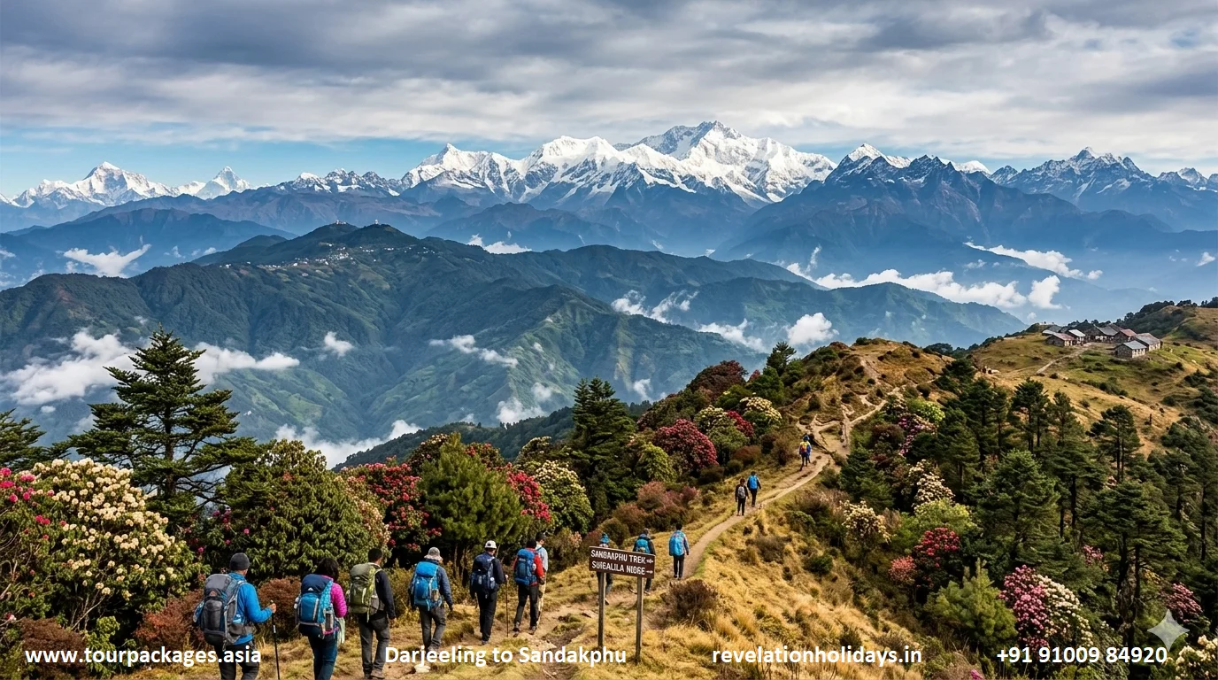
The Darjeeling–Sandakphu drive and trail along the Singalila Ridge — at 3,636 m, Sandakphu is West Bengal's highest point and offers a simultaneous view of four of the world's five highest peaks. Image: tourpackages.asia | revelationholidays.in
Distance
~80 km
Peak Visible
Kangchenjunga 8,586 m
Best Months
Oct–May (pre-monsoon)
Vehicle
Any car suitable
States
West Bengal, Sikkim
09
Uttarakhand — Kumaon Himalaya
Nainital to Munsiyari — The Kumaon Himalayan Drive
Naini Lake to the Panchachuli Panorama — Uttarakhand's Most Rewarding Highway
~210 km Nainital to MunsiyariMunsiyari: 2,200 mPanchachuli peaks visibleOpen: Year-round (best May–Oct)1–2 days recommended
The Nainital–Munsiyari drive — starting from the iconic Naini Lake and climbing through the Kumaon Himalaya to the foot of the Panchachuli massif. The signboard shows 210 km to Munsiyari, 105 km to Bageshwar. Image: tourpackages.asia | revelationholidays.in
The Nainital to Munsiyari drive is Uttarakhand's most underrated Himalayan highway — a 210 km journey through the heart of the Kumaon region that begins at the colonial lakeside hill station of Nainital and ends at a remote mountain outpost with one of the most dramatically positioned views of any Himalayan peak grouping accessible by road in India. Starting from the crescent of Naini Lake at 2,084 metres — the same lake that gives the town its name, surrounded by the colonial architecture of the British Raj era — the road descends to Bhowali, then climbs through oak and rhododendron forest to Almora at 1,651 metres: a Kumaoni hill town of genuine historical character, with a distinctive bazaar of traditional carved wooden shopfronts and a deep association with artists and writers (Jim Corbett, Swami Vivekananda, and Timothy Leary all lived or visited here at different points). The signboard visible in the drive's spectacular overview confirms the distances: Munsiyari 210 km, Bageshwar 105 km — each number a stage in an increasingly remote and rewarding journey.
From Almora, the road continues east through Bageshwar — an ancient confluence town at the meeting of the Saryu and Gomti rivers, significant in Kumaoni religious geography — and then climbs steadily through Chaukori (a viewpoint famous for its sunrise panorama of Panchachuli, Nanda Devi and Rajramba) and Berinag before the final approach to Munsiyari at 2,200 metres. The name means "place with snow," and it earns it: from the ridge above town, the Panchachuli Massif — five peaks between 6,334 m and 6,904 m that Kumaoni legend holds to be the five cooking fires (chulhas) of the Pandavas — fills the northern horizon with a wall of snow and ice at close quarters. Munsiyari is also the base for treks to the Milam, Ralam and Namik glaciers, making it a drive destination that rewards additional days on foot. The road itself, passing through the Balati Dhura wildlife reserve and the Sela meadows, offers sightings of Himalayan langur, barking deer and occasionally snow leopard tracks in winter. See India mountain packages including Kumaon circuits.
Distance
~210 km
Endpoint Altitude
Munsiyari 2,200 m
Best Months
April–June, Sep–Nov
Vehicle
Any car; SUV preferred
State
Uttarakhand
10
Kerala — Western Ghats
Munnar to Top Station — The Western Ghats Tea Garden Drive
Kerala's Highest Point — Rolling Tea Estates, Misty Ridges and the Tamil Nadu Escarpment
~32 km Munnar to Top StationTop Station: 1,700 mHighest point in KeralaBest: Oct–May2–3 hour return drive
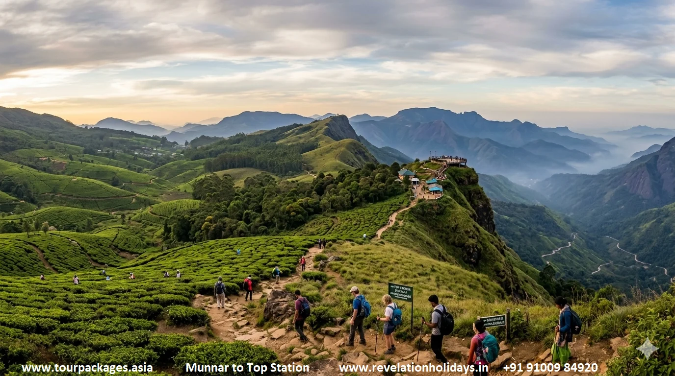
The Munnar–Top Station drive through the Kannan Devan Hills tea estates of Kerala — rolling emerald-green tea gardens beneath a dramatic sky, with the Tamil Nadu escarpment dropping away at the Kerala border. Image: tourpackages.asia | revelationholidays.in
The Munnar to Top Station drive is the most accessible and visually continuous mountain road experience in South India — a 32 km road through the Kannan Devan Hills of Kerala that passes through some of the most intensively maintained and visually spectacular high-altitude tea estates in Asia. The road begins in Munnar town at 1,600 metres — itself a remarkable landscape of tea-covered hills, clear mountain streams, and the colonial infrastructure of the Tata Tea company (which has managed these estates since 1964) — and climbs through progressively more dramatic terrain to Top Station at 1,700 metres on the Kerala–Tamil Nadu border. This is officially the highest point in Kerala accessible by road, and the border ridge delivers a view of startling drama: to the west, the layered ridges of the Western Ghats descend in sequence toward the Kerala coast; to the east, the Tamil Nadu plateau drops steeply away in one of the most spectacular escarpment views in peninsular India.
The drive is not primarily about altitude — Top Station is relatively low compared to the Himalayan drives on this list — but about the density and quality of what is visible from the road over its entire 32 km. At virtually every point, the road is flanked by the precise geometry of tea estate rows: the curving contours of the Kannan Devan Hills, planted to the ridge lines and bowl hollows in patterns that are essentially agricultural art at landscape scale. The morning light on these hills, particularly from October to February when the air is clear and the sky unobstructed, produces a quality of green that photographers specifically travel long distances to capture. The road is well-surfaced throughout, requires no special vehicle, and is manageable by any capable driver — making it the ideal mountain drive for those who want visual impact without the logistical demands of the Himalayan routes. The tea factory at Munnar (open for guided tours) and the nearby Eravikulam National Park (home to the endangered Nilgiri Tahr mountain goat) extend a Munnar visit comfortably to 2–3 days. Browse South India mountain tour packages for Kerala circuits.
Distance
~32 km (return ~64 km)
Highest Point
Top Station 1,700 m
Best Months
Oct–May (avoid monsoon)
Vehicle
Any car, well-maintained
State
Kerala (Western Ghats)
11
Meghalaya — Khasi Hills, North-East India
Shillong to Cherrapunji — The Waterfall Gorge Drive
The Wettest Road on Earth — Sacred Groves, Living Root Bridges and Nohkalikai Falls
~54 km Shillong to CherrapunjiCherrapunji: 1,484 mNohkalikai Falls: 340 mBest: Jun–Sep (monsoon) or Oct–May1.5 hr drive
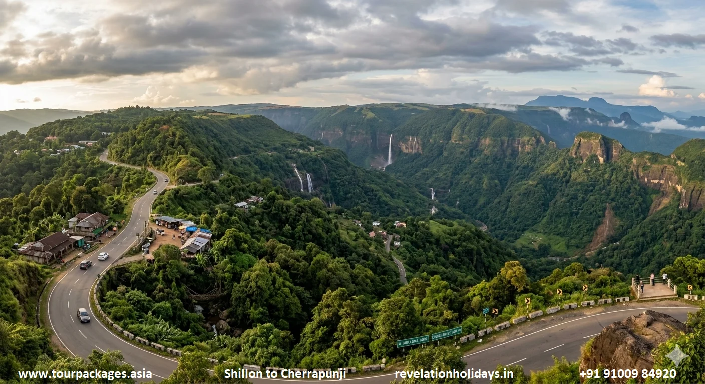
The Shillong–Cherrapunji road through the Khasi Hills of Meghalaya — the limestone escarpment drops dramatically into the Bangladesh plains, with Nohkalikai Falls (340 m) visible in the gorge. One of India's most dramatic road viewpoints. Image: tourpackages.asia | revelationholidays.in
The Shillong to Cherrapunji drive is the most dramatically different road experience on this list — not because of altitude (Cherrapunji sits at a modest 1,484 metres) but because of what the landscape does in the space of 54 km. The drive begins on the Shillong Plateau — a rolling grassy highland of the Khasi Hills at around 1,500 metres that has a distinctly un-Indian quality: the temperature is mild, the vegetation a mix of sacred groves (called law kyntang in the Khasi tradition, patches of forest preserved as sacred for over a thousand years and representing some of the last-surviving subtropical hill forest in the Meghalayan range), pine plantations and open grassland. The road then reaches the edge of the plateau and begins its descent toward Sohra (Cherrapunji) — at which point the landscape transforms with extraordinary abruptness.
The plateau edge is a limestone escarpment of dramatic geological formation, dropping steeply toward the Sylhet plains of Bangladesh 1,200 metres below. From the road, multiple waterfalls are simultaneously visible — including the Nohkalikai Falls at 340 metres, one of the tallest plunge waterfalls in the world and one of the most visually spectacular, particularly during and immediately after the monsoon when the volume of water is maximal. Cherrapunji and the nearby village of Mawsynram hold the records for the world's highest annual and single-month rainfall measurements, and the experience of driving this road in the monsoon — clouds building at eye level below you as you descend the escarpment, individual waterfalls appearing and disappearing in the mist, the road glistening and the gorges roaring with water — is one of the most atmospheric drives in Asia. In the drier months (October–May), the falls are smaller but the views are clearer, and the surrounding area offers the extraordinary living root bridges of the Khasi people — bridges woven from the aerial roots of Ficus elastica trees over decades into functional load-bearing structures, the finest examples at Nongriat requiring a 3,000-step descent. Explore North-East India packages including Meghalaya circuits.
Distance
54 km
Endpoint Alt.
Cherrapunji 1,484 m
Best Months
Jun–Sep (waterfalls); Oct–May (clear)
Vehicle
Any car suitable
State
Meghalaya
Quick Comparison — All 11 Drives
At-a-Glance Comparison — 11 Epic Mountain Drives in India
India's mountain roads demand a different approach from any other driving environment in the world. The five sections below cover everything a first-time or returning mountain driver needs to know before setting out.
The single most important investment for any Indian mountain road trip is the quality and condition of your vehicle. A high-clearance 4WD SUV — ideally the Toyota Innova Crysta, Mahindra Thar, Maruti Gypsy, or Bolero — is the standard choice for the Manali–Leh, Spiti, and Zanskar routes. The ground clearance requirement is real: river crossings on the Manali–Leh route during early season (June) can place water up to the door sills on a standard sedan. Always carry two spare tyres (not one) on any high-altitude route — the probability of a puncture on the Manali–Leh highway or Spiti circuit in a single vehicle over 400+ km of unpaved road approaches certainty. Tyre pressure should be reduced to approximately 25 PSI (from the standard 32–35 PSI) for rough mountain terrain — lower pressure increases the tyre's contact patch and grip on loose surfaces.
Engine performance degrades at altitude because of reduced oxygen density. At 4,500 metres, a naturally aspirated petrol engine produces approximately 55 percent of its sea-level power. This affects overtaking ability, climbing speed, and hill-start capability. Diesel engines lose less power at altitude (the fuel injection compensates partially). On the Manali–Leh route, allow twice the normal flat-road time for any section above 4,000 metres. Always check the engine oil and coolant before any high-altitude mountain drive — overheating is more common at altitude, particularly on sustained climbs. Revelation Holidays can arrange properly serviced mountain vehicles for all routes.
Altitude sickness (Acute Mountain Sickness, AMS) is a genuine medical risk on any drive that reaches above 3,000 metres, particularly for those arriving by air directly to Leh (3,524 m) or crossing the Manali–Leh route without prior acclimatisation. The standard protocol is to spend at least one day at 2,000–2,500 metres (Manali or Srinagar) before beginning any high-altitude driving, and to ascend no more than 500 metres per day above 3,000 metres. Symptoms of AMS — headache, nausea, fatigue, shortness of breath at rest, loss of coordination — should be taken seriously. The treatment is immediate descent; no further ascent until symptoms have fully resolved. Acetazolamide (Diamox) is the standard prophylactic medication, begun 24 hours before ascent and continued for 48 hours after reaching maximum altitude. Stay hydrated (3+ litres of water daily at altitude), avoid alcohol for the first 48 hours above 3,500 metres, and ensure adequate rest.
In addition to altitude concerns, UV radiation at high altitude is significantly higher than at sea level — full-strength sunscreen (SPF 50+), UV-protective sunglasses, and a hat are essential for any outdoor stop on the Manali–Leh or Spiti routes. The combination of thin air, high UV, and cold wind produces sunburn and dehydration simultaneously. Carry a basic first-aid kit including ORS sachets, analgesics, an antihistamine, antiseptic dressing materials, and a digital pulse oximeter — the oximeter is the single most useful piece of health monitoring equipment for high-altitude travel and costs approximately ₹800 at any pharmacy.
The permit requirements for India's mountain drives are specific, mandatory, and non-negotiable. Inner Line Permits (ILP) are required for Arunachal Pradesh (including the Tawang drive) for all Indian nationals who are not residents of Arunachal. These can be obtained online through the Arunachal Pradesh government portal (online.arunachalpradesh.gov.in) or through a licensed tour operator — the process takes 1–3 days. Protected Area Permits for Ladakh (specifically for Nubra Valley, Pangong Tso, and Dha-Hanu) are mandatory for all Indian and foreign nationals and are obtained through the Leh district administration or through a licensed local operator. Nathu La (Sikkim) requires a separate permit for Indian nationals obtainable in Gangtok with passport photo and ID — foreigners are not permitted to visit Nathu La. The Spiti Valley sections beyond Kaza require ILP for some border areas.
All permit applications require the following documents as standard: valid government-issued photo ID (Aadhaar card, passport, or voter ID), two passport-size photographs, and an itinerary. For group travel, one application covering all travellers is usually acceptable. Our team at Tour Packages Asia handles all permit applications as part of every packaged mountain drive — the administration is managed on behalf of guests with no additional charge, and permits are arranged well before departure to prevent last-minute complications at checkpoints.
Packing for a high-altitude Indian mountain road trip requires discipline — overloading a vehicle with unnecessary luggage reduces ground clearance and increases fuel consumption on climbs. The essential packing list: layering system covering the full temperature range from 25°C in valley floors to -5°C at high passes even in summer; waterproof outer layer; thermal base layers for overnight stops at Sarchu, Pang, or Chandratal; sturdy ankle-support hiking boots (flat-soled road shoes are insufficient if you need to push a stuck vehicle); headlamp with spare batteries; cash in small denominations (there are no ATMs between Manali and Leh); a fully charged power bank; downloaded offline maps (Google Maps offline, Maps.me, or the Border Roads Organisation route maps available as PDFs).
For the vehicle emergency kit: two spare tyres, a puncture repair kit (plug-and-seal type), a hand pump, tow rope, shovel for snow, basic toolkit, jump-start cables, and approximately 10 litres of emergency fuel in an approved jerry can. The last petrol pump before Leh on the Manali route is at Tandi (116 km from Manali); the next is at Pang (305 km from Manali). That 190 km gap — at high altitude with significant grade changes — requires careful fuel management. Our Ladakh packages include fully equipped, professionally serviced mountain vehicles with all emergency equipment as standard.
The summer driving window for India's mountain roads runs from late May through mid-October, but the specific weeks within that window matter enormously for different routes. June is the most adventurous month — roads have just opened, snow on high passes is still deep and in some places still being cleared, river crossings are at their most challenging due to snowmelt, and weather can change with extreme speed. It is also the most dramatic month visually: the contrast between residual snowfields and the first green of alpine vegetation produces a landscape of intense colour that photographers specifically seek. July–August brings full summer conditions and, in most of Ladakh, the reverse monsoon effect — the Himalayan rain shadow means the main mountain areas get limited precipitation while the Himalayan foothills are drenched. September is the preferred month for experienced mountain drivers: roads are at their best condition, passes are reliably open, afternoon weather is generally settled, and the summer crowds have begun to thin.
Always begin high-altitude mountain drives early in the morning (by 5–6 AM on the Manali–Leh route). This is not merely a scheduling preference — it is a safety requirement. Afternoons at high altitude bring two specific hazards: increased rockfall risk as daily freeze-thaw cycles loosen rocks (particularly on north-facing cliff sections that are in shade in the morning and sun-warmed in the afternoon), and reduced visibility due to cloud formation from 1–4 PM over high passes. Starting early also ensures you reach critical passes (Baralacha La, Tanglang La) before the midday convective cloud builds. Do not drive at night on any high-altitude mountain route — unmarked edges, unguarded drops, stray cattle, and unlit road workers' machinery make night mountain driving in India unacceptably dangerous.
India's Greatest Mountain Roads — We'll Drive Them With You
Fully supported mountain road trips with experienced local drivers, all permits handled, vetted accommodation and 24/7 emergency support. Focus on the view — we'll handle everything else.
15 Frequently Asked Questions — Mountain Drives in India
Everything you need to know before you start planning your India mountain road trip — from road conditions to altitude safety, vehicle choice to the best months.
For first-time mountain drivers in India, the Darjeeling to Pelling drive is the most accessible starting point — it requires no 4WD capability, no special permits, and the road is well-surfaced for most of its length, while delivering Kangchenjunga views that are among the finest in the Himalayan region. For those ready for more adventure, the Shimla to Kinnaur valley drive is the recommended step up — challenging enough to be exciting but manageable in a standard SUV for most of the route, and Sangla Valley and Chitkul are so rewarding that the difficulty of the gorge section is retroactively worthwhile. The Manali–Leh highway, while India's most famous mountain drive, is best approached with at least some prior mountain driving experience or with a professional driver. Our India mountain tour packages include professional local drivers on all high-altitude routes as standard.
The opening dates for India's mountain roads vary by location and annual snowfall. As a general guide: Srinagar–Leh road opens in late April–early May (Zoji La clearance); Manali–Leh highway opens in late May (Border Roads Organisation usually completes clearance by 20th–31st May); Spiti Valley's Kunzum La opens in mid-June; Sela Pass (Arunachal) is usually open April through November; Nathu La (Sikkim) is open year-round except during heavy snowfall periods in December–February. The Revelation Holidays team monitors road opening dates in real time and updates clients before departure. Always check with your operator or the Border Roads Organisation (Project Himank for Ladakh roads) for current conditions before travel.
The Manali to Leh highway is safe for summer travel when approached with appropriate preparation. The primary risks are: rockfall (particularly in the first weeks after opening in late May and June); river crossings that can deepen rapidly in afternoon snowmelt; mechanical failure due to altitude effects on vehicles; and AMS (altitude sickness) for drivers and passengers who ascend too quickly. Following basic safety protocols — early morning starts, never driving after dark, carrying two spare tyres, maintaining appropriate speed on gravel sections, and allowing one acclimatisation day in Manali before departure — reduces these risks to a level comparable with any challenging mountain drive internationally. The BRO (Border Roads Organisation) maintains teams along the route during the season and is generally responsive to accidents and blockages. Travelling with a professionally arranged guided tour eliminates most logistical risk factors.
The Spiti Valley permit situation has simplified in recent years. Indian nationals can now enter most of Spiti (including Kaza, Key Monastery, Chandratal, and the Kunzum La) without any permit. A Protected Area Permit (PAP) is still required for certain border areas close to the Tibetan frontier — specifically the Chango–Sumdo–Pooh stretch in Kinnaur and some areas in upper Spiti near the border. Foreign nationals require a Protected Area Permit for Spiti, obtainable from the Deputy Commissioner's office in Kaza or through a licensed tour operator (who can arrange it before departure). The permit is free for Indian nationals and has a nominal fee for foreigners. Our team at Tour Packages Asia handles all permits as part of any Spiti circuit package.
The Manali to Leh drive of 478 km requires a minimum of two days with an overnight stop at one of the roadside camps (Jispa at 3,200 m, Sarchu at 4,290 m, or Pang at 4,500 m). Starting before dawn on Day One and reaching Sarchu by afternoon, then completing the second half to Leh the following day with an early start, is the standard two-day itinerary. Three days is strongly recommended for first-time visitors and for those arriving from low altitude: the additional day allows a more comfortable acclimatisation stop at Jispa, time to properly explore the high passes without rushing, and reduces altitude sickness risk. The record for the drive (set by BRO contractors with heavy machinery) is approximately 5 hours — do not attempt anything close to this pace. Our Ladakh 6-day package uses a 2-day Manali-Leh transit as part of a fuller circuit.
The two roads offer categorically different experiences and both deserve to be driven at some point. The Manali to Leh highway offers higher passes (up to 5,328 m vs. 3,528 m for Zoji La), a more dramatic barren Himalayan landscape, and the quintessential high-altitude desert experience. The Srinagar to Leh road offers more cultural depth — passing through Kashmir's lush valley, the historical weight of Drass and Kargil, and the extraordinary Buddhist landscape of Lamayuru — and opens earlier in the season (April–May vs. late May). The ideal solution — and the one that most serious road-trippers choose — is to drive one route in and the other out: arriving in Leh via Manali and returning to Srinagar (or vice versa), creating a complete circuit that covers both roads, a stay on Dal Lake in Srinagar, and the full range of Ladakh sightseeing in between.
Yes — India's mountain regions (Ladakh, Himachal Pradesh, Sikkim, Arunachal Pradesh) are among the safest parts of the country for solo women travellers and women's groups. The mountain communities along all eight drives on this list have a tradition of hospitality and relatively low rates of the kind of harassment that can characterise some urban and plains destinations. The Ladakhi, Spitian, Kinnauri, Sikkimese and Arunachali communities are generally welcoming, respectful, and accustomed to independent travellers. Solo women road-trippers specifically rate the Darjeeling–Pelling drive, the Srinagar–Leh road (with Srinagar itself having a well-developed tourist infrastructure), and the Gangtok–Nathu La day drive as the most comfortable options. The Manali–Leh highway and Zanskar drives are more challenging for solo travel of any gender due to the remoteness; guided or group tours are the recommended format for these. Our team can arrange women-specific group itineraries on request — contact us via the planning form.
The Spiti Valley is at its best in July and August for those who can tolerate the summer heat in the lower valleys and want maximum access to all routes. September is the recommended month for those who prefer cooler temperatures, thinner crowds, and better visibility — the air is clearer in September than in the dusty summer months, the light quality for photography is exceptional, and the apple harvest in Kinnaur adds a visual and gastronomic dimension to the approach route. June offers the advantage of still-snowy high passes and no crowds but carries risks of road blockages from late-season snowfall and swollen river crossings from snowmelt. October sees the first snowfall of the new season and Kunzum La can close at any point from late October — driving Spiti in October requires careful monitoring of forecasts and a readiness to change plans. The Himachal mountain circuit operates June through October.
The Manali–Leh motorcycle journey is one of the most popular bucket-list rides in India and arguably in Asia — the Royal Enfield Himalayan and Bullet 500 are the classic choices, though any motorcycle with good torque at altitude, a robust chassis, and reliable brakes can complete the route. The specific considerations for motorcycles vs. cars: the experience of being completely exposed to the landscape, temperature, and altitude at every point is immeasurably more intense on a motorcycle; the risks of cold, altitude sickness, and falls are correspondingly higher. Key precautions for motorcycle riders: never ride above 4,000 metres without acclimatisation (AMS affects motorcycle riders harder because of cold and wind exposure on top of altitude effects); carry a full set of rain gear (afternoon showers at altitude can occur even in summer); ensure the motorcycle has been serviced within 500 km of the start; carry rope and basic tools. Rental motorcycles are available in Manali from multiple operators, with the Royal Enfield Himalayan being the most popular choice for the route. Our team at Revelation Holidays can arrange motorcycle-specific Ladakh itineraries.
Altitude sickness (AMS) is common on Indian mountain drives — particularly the Manali–Leh highway (which reaches 5,328 m), Spiti Valley (regularly above 4,000 m), and the Zanskar drive (Pensi La at 4,401 m). The key risk factor is the speed of ascent: flying directly to Leh and driving the next day is significantly more risky than driving from Manali and allowing an intermediate acclimatisation stop. Mild AMS — headache, mild nausea, fatigue — affects approximately 30–40 percent of first-time visitors to altitudes above 3,500 m. Severe AMS (confusion, loss of coordination, high-altitude pulmonary or cerebral oedema) is rare but medically serious. The prevention protocol: spend 1–2 days at 2,000–2,500 m before ascending higher; drink 3–4 litres of water daily; avoid alcohol and sleeping pills for the first 48 hours above 3,000 m; consider Acetazolamide (Diamox) 125–250 mg twice daily started 24 hours before ascent (consult a doctor first). Our Ladakh package itineraries are designed with appropriate altitude gain rates to minimise AMS risk.
This depends on what type of scenery you value most. For dramatic barren high-altitude landscape — the moon-and-ochre palette of rock, ice, and sky — the Manali–Leh highway and the Zanskar Valley drive are unrivalled. For lush alpine scenery combining forest, meadow, river, and snow — the Darjeeling–Pelling drive and the Tezpur–Tawang road are the finest in India. For geological spectacle — exposed rock strata in colours that seem impossible (ochre, rust, purple, grey-blue all in the same cliff face) — Spiti Valley and the Kinnaur gorge are the benchmark. For cultural landscape integration — where ancient human settlement (monasteries, dzongs, carved rock inscriptions) is woven into the natural geography — the Srinagar–Leh road through Lamayuru and Basgo is the most historically rich drive. Most experienced mountain travellers rate the Spiti circuit as the most sustained in its beauty across all landscape types simultaneously. Contact our planning team for a personalised recommendation based on your landscape preferences and available time.
The cost of a Manali to Leh road trip varies significantly by vehicle type, accommodation standard, group size, and whether you are self-driving or using a guided package. For a self-drive trip in your own vehicle: fuel costs for a standard SUV over 478 km at approximately 10 km/litre work out to roughly ₹5,000–6,000 (petrol). Tent camp accommodation at Sarchu or Jispa costs ₹1,500–3,000 per person per night including dinner and breakfast. Two days' food at roadside dhabas: approximately ₹500–800 per person. Total self-drive budget: approximately ₹8,000–12,000 per person for the highway transit (excluding vehicle hire, permits, and any Leh sightseeing). Our guided 6-day Ladakh package from Hyderabad — which includes flights, 5 nights' accommodation in Leh and Nubra, all meals (breakfast + dinner), vehicle and driver, and all permits — is available from tourpackages.asia with pricing on request. Contact our team for current seasonal pricing.
Mobile network coverage on India's mountain roads is patchy and in some stretches completely absent. On the Manali–Leh highway, there is no reliable network from approximately 30 km outside Manali to approximately 50 km outside Leh — a gap of roughly 400 km where most of the dramatic scenery is. BSNL is the most reliable network in Ladakh; Airtel and Jio have improved significantly in Leh town itself but have virtually no coverage on the high passes. Similarly, on the Spiti route, coverage is absent between Nako and the Kaza area. Essential offline preparations: download Google Maps offline for your complete route area before leaving the last town with data coverage; download all accommodation addresses and emergency contacts to your phone's local storage; take photographs of all key route information (permit numbers, emergency contacts, vehicle insurance) rather than relying on cloud documents. The BRO maintains satellite communication at their border posts on the Manali–Leh route and can relay emergency messages. Consider purchasing a guided package — our drivers carry BRO-registered emergency communication devices on all high-altitude routes.
Yes, and this is often the most rewarding way to experience India's mountain road culture. The most natural multi-drive combinations are: Manali–Leh + Srinagar–Leh as a complete Ladakh circuit (Manali in via NH-3, out via NH-1 to Srinagar, or reverse); Spiti Valley + Kinnaur–Chitkul as a 7–10 day Himachal high-altitude circuit beginning and ending in Shimla or Manali; Darjeeling–Pelling + Gangtok–Nathu La as a complete East Himalaya circuit of 4–5 days. For a multi-state mountain road epic covering different Himalayan zones, a 21–28 day circuit could cover: Delhi — Manali — Leh (via NH-3) — Srinagar (via NH-1) — return to Delhi — fly to Guwahati — Tezpur — Tawang — return — fly to Bagdogra — Darjeeling — Gangtok — Pelling — return. This covers four of the eight drives on this list across four different mountain states. Our India mountain tour specialists can design any multi-drive circuit itinerary.
Yes, completely. We specialise in fully supported India mountain road trip packages covering all eight drives on this list and any combination thereof. Our service includes: curated route planning with optimal driving days and acclimatisation stops; all permit applications handled before departure (Inner Line Permits, Protected Area Permits, tourist area permits); booking of vetted accommodation — from luxury camps at Chandratal and Pangong to boutique lodges in Leh and guesthouses in Kaza; professional local drivers with 10+ years of experience on the specific mountain routes (not general drivers repurposed for mountain roads); vehicles serviced before every tour with two spare tyres, emergency kit, and oxygen cylinder as standard; 24/7 WhatsApp support during the trip; and full flexibility to customise the itinerary around your specific interests, pace preferences, and fitness level. Our packages start from existing fixed itineraries — the 6-day Ladakh package from Hyderabad and the 6-day Himachal circuit — or we can build completely custom mountain drive itineraries. Contact us via the form below, WhatsApp +91 91009 84920, or email [email protected].
Plan Your India Mountain Drive
Tell us which roads call to you — we'll build the perfect high-altitude road trip
Explore More of India — Mountains, Heritage, Beaches & Beyond
Tour Packages Asia curates journeys across India's most extraordinary landscapes — from the Himalayas to the coast and everywhere in between.