10 Most Scenic Coastal Road Trips in India — Drives Worth Every Kilometre
Revelation
March 18, 2026
Posted By : Admin
10 Most Scenic Coastal Road Trips in India — Drives Worth Every Kilometre
Embark on 10 of the most scenic coastal road trips in India, where endless ocean views meet vibrant culture and adventure. From the Konkan coast and East Coast Road to Kerala’s backwaters and Goa’s shoreline, each journey offers breathtaking beaches, charming towns, and memorable experiences. Perfect for families, bikers, and road trip enthusiasts, these coastal drives blend natural beauty, cultural richness, and the joy of exploring India’s spectacular coastline.
India Road Trips · Coastal Highways · Sea, Salt & Shore
10 Most Scenic Coastal Road Trips in India Every Person Must Experience Once
India has 7,500 km of coastline. These ten roads run the finest stretches of it — from the Konkan's laterite cliffs to Kerala's backwater palms, from Tamil Nadu's temple shores to Odisha's golden beach highway.
Tour Packages Asia · · 10 Drives · 3 Coastlines · 4,500+ km of Ocean Roads
India's coastline — 7,500 km of it, shared between the Arabian Sea to the west, the Bay of Bengal to the east, and the Indian Ocean at the tip — is among the most varied and visually dramatic of any country on earth. In a single day's drive along the right stretch of this coast, you can move through a dozen landscapes: fishing villages where wooden boats are dragged up on silver sand before dawn, sea forts built by Portuguese and British and Maratha naval commanders, estuaries where freshwater rivers slow and widen before meeting the salt, cliff beaches of startling red laterite, and stretches of open coconut-palm highway where the Arabian Sea is visible in flashes between the trunks, blue and enormous, at every bend. The smell of salt and fish and brine enters the car hours before you see the water.
This guide profiles 10 of India's most rewarding coastal road trips — selected not just for the quality of the seascape but for the completeness of the experience the road provides: the food, the stops, the history, and the specific quality of light that each coastline delivers at different times of year. Whether you are driving from Mumbai to Goa for the first time or exploring the less-known stretches of the Odisha coast, these drives will remind you that in India, the journey is always the destination. Explore all India tour packages and plan your coastal road trip today.
Each drive below is rated for scenic value, road quality, cultural depth, and ease of driving — with the key distance numbers that travellers search for most, the best stops, and honest advice on what the road actually feels like from the driver's seat.
1
Maharashtra → Goa · Arabian Sea
Mumbai to Goa — The Konkan Coast Classic
NH66 · India's Most Iconic Coastal Road Trip
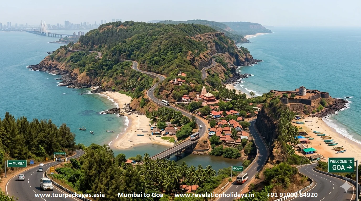
Distance: 599 km via NH66Drive time: 11–13 hours (2-day recommended)Best: Oct–MarHighway: NH66Difficulty: Easy–Moderate
Mumbai to Goa NH66 Konkan coast — the legendary road trip past Alibag, Ganpatipule, Tarkarli and Sindhudurg Fort along the Maharashtra Arabian Sea coast. Image: tourpackages.asia | revelationholidays.in
Mumbai to Goa distance by road: 599 km via NH66 (Konkan coastal) | 460 km via NH48 (inland via Pune)
The Mumbai to Goa road trip is India's most romanticised coastal drive — the one immortalised in Dil Chahta Hai, debated at every office travel planning meeting, and executed annually by hundreds of thousands of drivers who leave the city on a Thursday night and arrive at Goa's beaches by Saturday morning. The route via NH66 (the old NH17, running 599 km along the Konkan coast from Panvel through Mahad, Chiplun, Ratnagiri, Malvan, and Sawantwadi to Panaji) is the scenic choice — slower than the inland NH48 via Pune and Kolhapur, but delivering a quality of road experience that the inland highway simply cannot match. The NH66 traces the western edge of the Konkan coastal strip — a narrow band of land between the Western Ghats and the Arabian Sea that is simultaneously one of India's most fertile agricultural regions (the Alphonso mango belt, the cashew nut country, the Konkani fish curry heartland) and one of its most historically layered (Shivaji's sea-fort empire, the Portuguese colonial ports, the medieval temple complexes of Ganpatipule).
The landscape on the NH66 Konkan drive changes with a frequency that keeps the driver perpetually engaged. Dense laterite-red cliff faces alternate with green paddy valleys; rivers are crossed on bridges where, below, fishing boats move between backwater and open sea; the road climbs through ghats thick with mango orchards and descends to sea-level estuaries where the smell of salt enters the car through every vent. The major stops — Alibag (the nearest beach town to Mumbai, with the Kulaba sea-fort accessible at low tide), Ganpatipule (where the beach and temple sit at the base of a forested headland), Tarkarli (the clearest water on the Konkan coast, with excellent snorkelling), Malvan (Sindhudurg Fort, a 17th-century island fortress built by Shivaji, visible from the waterfront) — each reward a half-day stop. See our India tour planning service for customised Mumbai–Goa itineraries.
Alibag (103 km from Mumbai)
Kulaba sea fort, Alibaug beach, Nagaon beach
Ganpatipule (375 km)
Swayambhu temple, clean beach, backwater cruise
Tarkarli (490 km)
Crystal clear sea, scuba diving, Malvan seafood
Sindhudurg Fort (500 km)
17th-century island sea fort built by Shivaji Maharaj
Amboli Ghat (560 km)
Spectacular waterfall viewpoint on the Sahyadri edge
Total Distance
599 km (NH66)
Inland Route
460 km (NH48 via Pune)
Best Months
Oct–Mar
Ideal Duration
2 days minimum
Sea
Arabian Sea
2
Kerala · Arabian Sea · God's Own Country
Kochi to Thiruvananthapuram — Kerala's Malabar Coast Highway
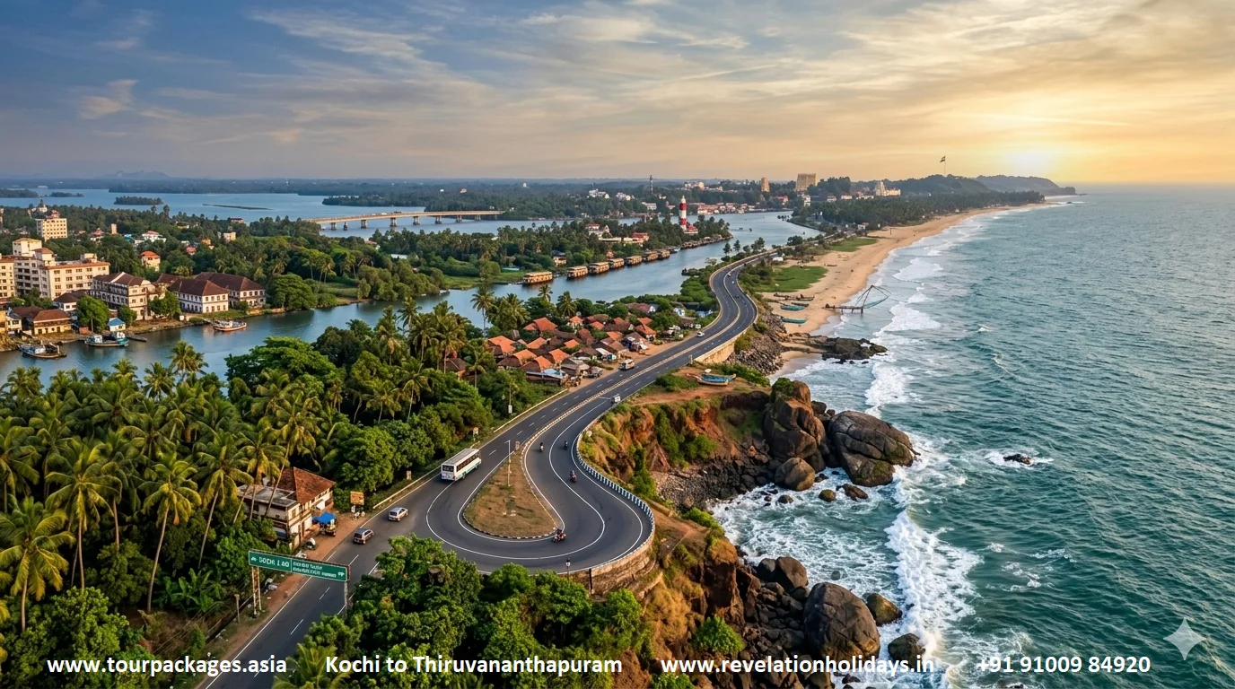
NH66 Kerala · Backwaters, Cliff Beaches and the Spice Coast
Distance: ~220 km (Kochi to Trivandrum)Drive time: 4–5 hours direct; 2 days idealBest: Sep–MarHighway: NH66 KeralaFull coast: 450 km (Kannur to Trivandrum)
Kerala's NH66 Malabar Coast highway — Kochi to Thiruvananthapuram through backwater canals, coconut palm groves and the Arabian Sea shoreline. Image: tourpackages.asia | revelationholidays.in
Kochi to Thiruvananthapuram by road: ~220 km via NH66 | ~4.5 hours direct drive
The Kerala coastal highway — the NH66 running the length of Kerala's western coast from Kasaragod in the north to Thiruvananthapuram in the south — is a road of a completely different character from the Konkan drive. Where the Konkan is dramatic, cliff-edged, and rapidly varied, the Kerala coast is pastoral, languid, and saturated with a specific quality of lush tropical green that is unique to the region. The road runs close to the coast but not always on it, weaving through a landscape of coconut palms, rubber estates, Catholic churches of extraordinary architectural exuberance, mosques, temples, and the backwater canal system that parallels the coast for much of its length. The Kochi to Thiruvananthapuram section (approximately 220 km) is the most varied and most rewarding.
The key stops on the Kerala coastal drive read like a Kerala tourist brochure, but each earns its place independently of any promotional writing. Alleppey (Alappuzha) — the backwater town at the junction of the Vembanad Lake and the canal network — is the point where most travellers stop for at least a night, for a houseboat experience on the waterways. Our 5-day Kerala tour package includes a full houseboat night at Alleppey. Kollam, 70 km south of Alleppey, is a historic trading port that marked the southern end of the spice trade route — the Ashtamudi Lake here, a sheltered estuary of remarkable beauty, is the starting point for the eight-hour backwater boat journey to Alleppey that is one of Kerala's finest slow-travel experiences. Varkala, 50 km north of Thiruvananthapuram, is the most dramatic point of the entire Kerala coast: a 15-metre red laterite cliff running for nearly 2 km above a crescent beach, with the cliff-top promenade of cafes and guesthouses offering an uninterrupted view of the Arabian Sea horizon. Plan via Revelation Holidays for exclusive Kerala coast circuits.
Alleppey / Alappuzha (84 km from Kochi)
Backwater houseboat, Vembanad Lake, canal network
Marari Beach (94 km)
Quiet, unspoiled beach — one of Kerala's best kept secrets
Kollam (155 km)
Ashtamudi Lake, cashew factory tours, backwater ferry
Varkala (195 km)
Cliff beach, natural springs, Janardana Swami Temple
Kovalam (215 km)
Lighthouse beach, Hawah beach, Ayurvedic resort strip
Kochi–Trivandrum
~220 km
Full Coast Length
450 km (Kannur–TVM)
Best Months
Sep–Mar
Ideal Duration
2–3 days
State
Kerala
3
Tamil Nadu · Bay of Bengal
Chennai to Pondicherry — The East Coast Road
ECR · Bay of Bengal Beside You the Whole Way
Distance: ~150 km (Chennai to Pondicherry)Drive time: 3–4 hoursBest: Nov–FebHighway: East Coast Road (ECR / SH-49)Easy weekend drive
The East Coast Road (ECR) Chennai to Pondicherry — Bay of Bengal on the left the whole way, with Mahabalipuram Shore Temple and the French Quarter of Pondicherry as the highlights. Image: tourpackages.asia | revelationholidays.in
Chennai to Pondicherry distance by road: ~150 km via ECR | ~3.5 hours drive
The East Coast Road — the ECR, running south from Chennai's southern suburbs along the Bay of Bengal to Pondicherry and beyond — is South India's most popular weekend coastal drive, and the one that best delivers on the promise of "the sea beside you the whole way." For much of its 150 km from Chennai to Pondicherry, the ECR runs within sight of the Bay of Bengal: not the dramatic Arabian Sea cliff scenery of the Konkan or Kerala, but a steady, calming presence of grey-blue sea to the east, fishing villages with their upturned wooden Kattumaram boats on the sand, and the kind of open sky available only on a flat coastline that makes everything feel simultaneously wide and intimate. The road itself is smooth, well-maintained, and largely free of the heavy truck traffic that affects inland Tamil Nadu highways — making it one of the most comfortable long drives in South India.
The stop that anchors the ECR drive is Mahabalipuram (Mamallapuram), 58 km from Chennai — a UNESCO World Heritage Site of extraordinary richness, where a sequence of 7th and 8th-century Pallava rock-cut temples, monolithic rathas (chariot-shaped temples), and relief carvings culminates in the Shore Temple: a twin-spired Shiva temple built directly on the beach with the sea lapping its compound walls. The view of the Shore Temple from the beach at dawn — the stone tower against the light, the sound of waves — is one of the most affecting heritage experiences in India. Pondicherry (Puducherry) at the road's southern end is a French colonial town of remarkable architectural coherence — the White Town's yellow-washed villas, Rue de la Marine, the Botanical Garden, and Promenade Beach all within easy walking distance of each other — making it the ideal drive destination for a cultural weekend from Chennai. See our South India weekend getaway guide for combined circuits.
Muttukadu (30 km from Chennai)
Backwater boating, kayaking, watersports complex
Mahabalipuram / Mamallapuram (58 km)
UNESCO Shore Temple, Arjuna's Penance, Five Rathas
Dakshina Chitra Museum (52 km)
Living heritage museum of South Indian architecture and crafts
Auroville (140 km)
International township, Matri Mandir meditation centre
Pondicherry (150 km)
French Quarter, Promenade Beach, Sri Aurobindo Ashram
Distance
~150 km
Drive Time
3–4 hours direct
Best Months
Nov–Feb
Ideal Duration
2-day weekend
Sea
Bay of Bengal
4
Maharashtra Interior Konkan · Arabian Sea
The Konkan Deep Drive — Pune to Sindhudurg via Coastal Villages
Off the Tourist Trail — Sea Forts, Alphonso Mango Orchards and Hidden Beaches
Distance: ~350 km (Pune to Sindhudurg)Drive time: 7–8 hoursBest: Nov–AprRoute via Tamhini Ghat / Kashedi GhatGhat + Coastal combination
The Konkan Deep Drive from Pune to Sindhudurg — Tamhini Ghat forest descent to the Maharashtra coast, Harihareshwar cliff temple and the turquoise water at Tarkarli. Image: tourpackages.asia | revelationholidays.in
Pune to Sindhudurg distance by road: ~350 km via Tamhini Ghat + coastal | ~7.5 hours
The Konkan deep drive — the Pune to Sindhudurg route that most travellers miss by heading straight to Goa — covers the most unspoiled stretch of the Maharashtra coast, where tourism infrastructure is thinner, the beaches are empty, and the fish is fresher than anywhere in the state. The route descends from the Deccan plateau through Tamhini Ghat — one of the most spectacular of all the Western Ghats passes, with the dense Sahyadri forest closing over the road and waterfalls visible from multiple viewpoints in the monsoon — before reaching the coastal plain at Mahad and following the coast south. Harihareshwar — a small cliff-top temple town where a Shiva temple stands above a bay of extraordinary beauty, considered the Dakshina Kashi (Southern Varanasi) of the Konkan — is the first major coastal stop, 210 km from Pune, and already one of Maharashtra's finest sea-coast experiences.
South of Harihareshwar, the road passes through Dapoli (a Konkan hill station with proximity to several empty beaches), Ratnagiri (birthplace of Lokmanya Tilak, home to Ratnadurg Fort, and the capital of Alphonso mango country — May visits coincide with the harvest season and the mango market is extraordinary), and Devgad before reaching the southernmost district of Sindhudurg. Tarkarli, the star of the Sindhudurg coast, has the clearest water on the entire Maharashtra coast — a turquoise shallows over white sand that make it, on a calm December morning, comparable in beauty to anything in Southeast Asia. The South India coastal circuits from our portfolio can be extended to include this stretch.
Tamhini Ghat (80 km from Pune)
Western Ghats forest pass, spectacular monsoon waterfalls
Harihareshwar (210 km)
Cliff temple, unspoiled beach, Dakshin Kashi shrine
Clearest water in Maharashtra, scuba diving, Sindhudurg Fort
Distance
~350 km
Drive Time
7–8 hours
Best Months
Nov–Apr (May for mangoes)
Ideal Duration
2–3 days
State
Maharashtra
5
Odisha · Bay of Bengal
Puri to Konark — The Odisha Marine Drive
30 km of Uninterrupted Bay of Bengal — Sacred Shores and the Sun Temple
Distance: ~35 km (Puri to Konark)Drive time: 45 minutesBest: Oct–FebUNESCO: Konark Sun TempleEasiest scenic coastal drive in India
Puri to Konark Odisha Marine Drive — 35 km of Bay of Bengal seafront ending at the 13th-century UNESCO Konark Sun Temple. Image: tourpackages.asia | revelationholidays.in
Puri to Konark distance by road: ~35 km via Marine Drive | ~45 minutes
The Puri to Konark Marine Drive is India's shortest great coastal drive — just 35 km — but it delivers a quality of sea-view experience that many much longer drives fail to achieve. The road runs almost entirely along the Bay of Bengal shoreline, with the ocean visible on the left for virtually the entire route and casuarina tree groves on the right, creating a seafront promenade drive that few other Indian roads match for sheer visual clarity and oceanic presence. Starting from the sacred Jagannath Temple town of Puri — one of the four Dhams of Hindu pilgrimage, where the annual Rath Yatra chariot festival draws over a million devotees in June–July — the road ends at Konark, home to the 13th-century Sun Temple: a UNESCO World Heritage Site built in the form of the sun god's colossal chariot with 24 stone-carved wheels, considered one of the finest examples of medieval Indian architecture.
The drive can be extended north from Konark toward Chandrabhaga Beach — a cleaner and less-crowded stretch of Bay of Bengal coast — and further to the Chilika Lake area (Asia's largest brackish water lagoon, 40 km south of Puri, home to Irrawaddy dolphins and vast flocks of migratory flamingoes in winter). The Odisha coast between Puri and Konark also has a network of dedicated tribal village roads — diversions through Raghurajpur (a heritage crafts village of the Odissi pattachitra painters), the fishing village of Balighai at the mouth of the Kushabhadra river, and the surprisingly grand promenade at Chandrabhaga. For a longer Odisha coastal circuit, the route can continue north toward Bhubaneswar — combining beach, UNESCO temple, and the extraordinary concentration of Kalingan temple architecture in the capital. Explore East India tour packages for Odisha circuits.
Puri Beach (start)
Sacred Jagannath Dham, sunrise swimming beach, Rath Yatra
Chandrabhaga Beach (28 km)
Clean, uncrowded; Magha Saptami festival in Feb
Konark Sun Temple (35 km)
UNESCO 13th-century chariot temple, stone wheels, erotic sculptures
Distance
~35 km
Drive Time
45 minutes
Best Months
Oct–Feb
UNESCO Site
Konark Sun Temple
State
Odisha
Let the Road Find the Sea for You
From Mumbai to Goa's sun-bleached Konkan highway to Kerala's backwater-fringed coast — our travel specialists craft every coastal road trip around your pace, your stops, and your version of the perfect Indian seaside journey.
Rameswaram to Dhanushkodi — The Ghost Road at Land's End
India's Most Dramatic Coastal Drive — Sacred Island, Ruined Town, Two Seas
Distance: ~18 km (Rameswaram to Dhanushkodi)Drive time: 30–45 minutes (road ends at Dhanushkodi)Best: Oct–MarRameswaram from Chennai: 580 kmUnique: Two seas visible simultaneously
Rameswaram to Dhanushkodi — the sandbar road at the tip of India where two seas are visible simultaneously and the ghost town of Dhanushkodi marks land's end. Image: tourpackages.asia | revelationholidays.in
Chennai to Rameswaram distance: ~580 km via NH32 | ~10–11 hours drive
The drive from Rameswaram to Dhanushkodi is the most otherworldly coastal road experience in India — a 18-km road across a narrow sandbar that forms the southern tip of Pamban Island in the Palk Strait, with the Palk Bay to the north and the Bay of Bengal to the south, both visibly blue on a clear day and sometimes separated by a strip of sand barely 200 metres wide. The road ends at Dhanushkodi — a ghost town obliterated by the 1964 cyclone, where the ruins of a railway station, post office, church and residential buildings protrude from the sand. At the very tip, you stand at the confluence of the Palk Strait, the Bay of Bengal, and the Indian Ocean, looking across the Ram Setu (Adam's Bridge) — the chain of limestone shoals that Hindu tradition holds to be the bridge built by Rama's army to Lanka. Sri Lanka is visible on clear days, 30 km away. It is a place of geological, spiritual, and dramatic power simultaneously.
Rameswaram itself — reached by the extraordinary Pamban Bridge, a 2-km sea bridge across the Palk Strait that was India's longest sea bridge when built in 1914 — is the spiritual anchor of the drive. The Ramanathaswamy Temple, one of the twelve Jyotirlinga shrines and one of the Char Dham pilgrimage sites, has the longest temple corridor in Asia — over 1.2 km of carved granite columns in its prakarams. The combination of pilgrimage depth, geological drama, and the specific eerie beauty of the Dhanushkodi ghost town makes this drive unique among all Indian coastal routes. The drive from Madurai to Rameswaram (approximately 170 km, 3 hours) adds a UNESCO heritage temple (Meenakshi Amman) at one end and the land's end experience at the other, making it one of South India's finest single-day road experiences. Our Bangalore to Rameswaram temple tour covers this route comprehensively.
Pamban Bridge (3 km from Rameswaram town)
India's first sea bridge; railway bridge beside the road is spectacular
1964 cyclone ruins; confluence of two seas; Ram Setu viewpoint
Rameswaram–Dhanushkodi
18 km
Chennai–Rameswaram
~580 km
Best Months
Oct–Mar
Unique Feature
Two seas at one point
State
Tamil Nadu
7
Andhra Pradesh · Bay of Bengal
Visakhapatnam (Vizag) Beach Road — The City of Destiny's Coastal Drive
RK Beach to Bheemunipatnam — Submarine Museum, Kailasagiri and the Bay of Bengal Promenade
Distance: ~25 km (RK Beach to Bheemunipatnam)Drive time: 30–45 minutes (leisurely 2 hours)Best: Oct–MarExtended: Vizag to Puri ~450 km (AP–Odisha coast)Urban coastal drive
Vizag beach road from RK Beach to Bheemunipatnam — Andhra Pradesh's Bay of Bengal coastal promenade with Kailasagiri hill, Rushikonda beach and the submarine museum. Image: tourpackages.asia | revelationholidays.in
Vizag to Puri distance by road: ~450 km via NH16 and NH316 | ~9 hours drive
Visakhapatnam's beach road is the finest urban coastal promenade drive in South India — a long seafront boulevard running from RK Beach (Ramakrishna Beach) northward along the Bay of Bengal through the beach neighbourhoods of Lawson's Bay, Rushikonda, and Bheemunipatnam, covering 25 km of largely uninterrupted coastline within the city limits. Unlike many Indian seaside city drives, the Vizag beach road actually puts the sea in front of the driver for most of its length — the Bay of Bengal is to the right throughout, separated from the road only by a walkway and the sand. The Kailasagiri hill park, midway along the route on a clifftop, offers a panoramic view of the entire bay that rivals any coastal viewpoint in Andhra Pradesh.
The extended Vizag to Puri coastal drive (450 km, approximately 9 hours) takes the NH16 north through the Andhra Pradesh and Odisha coastal districts — through Srikakulam, Naupada, Berhampur, and Chilika Lake — combining the urban beach drive with the spectacular Chilika Lake waterway (Asia's largest coastal lagoon, famous for Irrawaddy dolphins and migratory birds) and the Odisha temple coast. The Borra Caves near Araku Valley, 90 km inland from Vizag, add a natural wonder dimension to the extended itinerary. For a combined coastal and hills circuit from Vizag, see our India tour packages including Andhra coastal circuits.
RK Beach / Ramakrishna Beach
INS Kurusura Submarine Museum, Kali Temple, Vizag port backdrop
Kailasagiri Hill (12 km)
Clifftop park, ropeway, panoramic Bay of Bengal views
Rushikonda Beach (18 km)
Blue flag beach, clean water, water sports
Bheemunipatnam (25 km)
Heritage Dutch cemetery, estuary beach, colonial architecture
City Beach Drive
25 km
Vizag–Puri
~450 km
Best Months
Oct–Mar
Ideal Duration
Day drive or extended 2-day
State
Andhra Pradesh
8
Karnataka · Arabian Sea
Mangalore to Gokarna — The Karnataka Coastal Highway
NH66 Karnataka · Sacred Beaches, Ancient Temples and Sea-Fort Country
Distance: ~240 km (Mangalore to Gokarna)Drive time: 4–5 hoursBest: Oct–MarHighway: NH66Also: Udupi, Murudeshwara, Gokarna
Mangalore to Gokarna Karnataka coast highway — NH66 past Udupi, the Murudeshwara Shiva statue, Mirjan Fort and the sacred beaches of Gokarna. Image: tourpackages.asia | revelationholidays.in
Mangalore to Gokarna distance: ~240 km via NH66 | ~4.5 hours
The Karnataka coastal highway — the NH66 from Mangalore northward through Udupi, Kundapur, Bhatkal, Murudeshwara, and Gokarna — is among the finest stretches of coastal driving in India and the section that most directly delivers on the "sea beside you constantly" promise. The road runs along the narrow Coastal Karnataka strip where the Western Ghats come close to the sea, creating a landscape of extraordinary compressed drama: forested hills to the east, rice paddy terraces descending toward the road, the Arabian Sea opening and closing to the west as the road curves around rocky headlands and palm-fringed estuaries. Udupi — 60 km north of Mangalore — is the food capital of South Indian vegetarian cooking (the Udupi hotel chain that operates across India originates here), and the Krishna Temple at the centre of town is one of the most beautifully maintained temple complexes in Karnataka.
Murudeshwara, 160 km from Mangalore, is the most visually dramatic stop on the Karnataka coast: a 123-metre Shiva statue on a headland above the sea — the world's second-tallest Shiva statue — visible from 20 km away on the highway and dramatic at any time of day, but especially at dusk when the statue and the clifftop Murudeshwara Temple are lit against the Arabian Sea horizon. Gokarna, 240 km north of Mangalore and 30 km from the Goa border, is the holiest town on the Karnataka coast — the Mahabaleshwara Temple here is one of the most sacred Shiva shrines in South India — and the surrounding beaches (Om Beach, Half Moon Beach, Paradise Beach) are some of the most beautiful and unspoiled on the entire west coast of India. See our Gokarna weekend guide from Bengaluru.
Udupi (60 km from Mangalore)
Krishna Temple, Udupi cuisine, St. Mary's Island nearby
India's Southernmost Tip to the Sacred Island — A Pilgrimage Drive of Rare Beauty
Distance: ~280 km (Kanyakumari to Rameswaram)Drive time: ~5 hoursBest: Oct–MarHighlights: Tip of India, Tiruchendur, Pamban Bridge3 seas visible at Kanyakumari
Kanyakumari to Rameswaram southern arc — from the three-sea confluence at India's tip along the Tamil Nadu coast past Tiruchendur to the Pamban Bridge and Rameswaram island. Image: tourpackages.asia | revelationholidays.in
Kanyakumari to Rameswaram distance: ~280 km via coastal NH44 | ~5 hours
The Kanyakumari to Rameswaram drive traces the southernmost arc of mainland India — the stretch where the Indian peninsula ends and the two flanking seas (Arabian Sea and Bay of Bengal) converge at the Indian Ocean tip. Beginning at Kanyakumari — where you can watch the sunrise and sunset over two different seas from the same point, where the Vivekananda Rock Memorial rises from the sea 500 metres offshore, and where the holy confluence of the three oceans draws pilgrims year-round — the road heads north-east along the Bay of Bengal coast through Thiruvananthapuram (crossing briefly into Kerala), Nagercoil, and the fishing towns of the far southern Tamil Nadu coast. The landscape is intensely coastal throughout: the sea is close and visible, the roads lined with coconut palms and fishing hamlets, and the light has a particular quality of brightness from the open ocean on both sides of the peninsula that is specific to this southernmost latitude.
The key stopover is Tiruchendur — 170 km from Kanyakumari — home to the only coastal Murugan temple of the Arupadaiveedu (six battle camps of Murugan), where the temple is built directly on the sea shore and the sound of waves merges with the sound of bells during puja. The town of Tuticorin (Thoothukudi) nearby is a major pearl-fishing port and the base for boat trips to the Gulf of Mannar Marine National Park, one of India's richest coral reef systems. The drive ends with the Pamban Bridge crossing and the Rameswaram causeway — arriving at the sacred island where the drive from the southern tip achieves its natural pilgrimage completion. Our South India temple tour covers Kanyakumari and Rameswaram in a single circuit.
Kanyakumari (start)
Three-sea confluence, sunrise/sunset, Vivekananda Rock, Thiruvalluvar Statue
Tiruchendur (170 km)
Murugan temple on the sea; only coastal Arupadaiveedu shrine
Tuticorin / Thoothukudi (210 km)
Pearl fishing port; Gulf of Mannar Marine National Park
Vizag to Araku Valley — Coast, Coffee and the Eastern Ghats
Bay of Bengal to Tribal Hill Country — India's Most Surprising Road Trip Combination
Distance: ~114 km (Vizag to Araku)Drive time: ~3 hoursBest: Oct–MarAltitude: Araku at 910 mCoastal + Hill combination
Vizag to Araku Valley — from Bay of Bengal coastline through Borra Caves and the Eastern Ghats to Araku's award-winning tribal coffee highland at 910 m. Image: tourpackages.asia | revelationholidays.in
Visakhapatnam to Araku Valley distance: 114 km via NH216 | ~3 hours drive
The Vizag to Araku Valley drive is the one entry on this list that begins at the coast and climbs into the hills — but it earns its coastal credentials fully, because the morning begins at RK Beach on the Bay of Bengal and ends in a coffee-growing tribal highland at 910 metres that has a climate, culture, and landscape completely different from anything on the coast below. The drive from Vizag's beachfront through Bheemili (the Dutch colonial beach town), Anantagiri Hills (a coffee plantation belt in the Eastern Ghats foothills), and the spectacular Ananthagiri Coffee plantations is one of the most compressed landscape transitions in South India — from sea level to 910 metres in under 100 km.
The Araku Valley itself — a high plateau of the Eastern Ghats surrounded by tribal communities of the Kondh and Gadaba peoples — is famous for its Araku Valley coffee (a speciality single-origin coffee grown in the shade of forest trees by tribal farmers, winning awards at international competitions) and for the Borra Caves (30 km short of Araku on the NH216 — a system of stalactite and stalagmite caves of extraordinary size and beauty, discovered in 1807, and the largest caves in the Eastern Ghats). The tribal museum at Araku, the coffee plantations, the Dumbriguda waterfalls, and the panoramic views from the valley rim complete an itinerary that combines a morning by the Bay of Bengal with an afternoon above the clouds. The Araku Vistadome train from Vizag — an alternative to the drive — is itself one of the most scenic rail journeys in South India. See South India packages including Vizag and Andhra coast circuits.
Bheemunipatnam Beach (start extension)
Bay of Bengal, Dutch cemetery, estuary
Borra Caves (85 km from Vizag)
Largest cave system in Eastern Ghats; stalactites 150,000 years old
India's coastal roads require a different approach from mountain drives. The five sections below cover everything you need before you set out.
The best season for coastal road trips in India is October to March across all three coastlines — west, east, and south. The southwest monsoon (June–September) affects the Arabian Sea coast most severely: the NH66 Konkan and Kerala sections experience extremely heavy rainfall (the Konkan coast receives over 3,000 mm annually), making driving slippery and some river crossings dangerous. The Bay of Bengal coast (ECR, Puri–Konark) has a northeast monsoon (October–December) which can produce rough weather but is generally manageable. December and January are the peak months for most coastal drives — dry, clear, temperatures around 22–28°C, and the sea at its most photogenic under the winter sun.
For the Mumbai to Goa drive specifically, avoid April–May (extreme heat and humidity on the Konkan coast reaches 38°C+ with 80%+ humidity). The monsoon drive (July–August) is spectacular for waterfall-chasing but demands significant preparation: the NH66 is being widened in sections and diversions can add hours; carry a physical map and check road conditions via the Maharashtra State Road Development Corporation or BRO alerts before departure.
Coastal food is one of the primary reasons to drive India's sea-edge roads rather than flying. Each coastline has a distinct culinary identity that is inseparable from the road trip experience. On the Konkan coast (Mumbai–Goa), the essential roadside food is the Konkani thali — a meal of red fish curry, rice, sol kadhi (a pink coconut milk and kokum digestive drink), and fried pomfret or surmai (kingfish), available at dozens of small dhaba-style restaurants in Malvan, Devgad, and Ganpatipule for under ₹250. The Kerala coast road rewards with karimeen pollichathu (pearl spot fish steamed in banana leaf), toddy-shop fish curry, and appam-with-stew in Catholic fishing villages. The Udupi coast (Karnataka) is the spiritual home of South Indian vegetarian cooking — every town has a temple canteen-style restaurant serving idli, sambar, and rasam of a standard that no city Udupi chain matches.
A note on timing food stops: coastal village restaurants often close between 3 PM and 6 PM for the afternoon break, and some small fish curry places run out of the day's fresh catch by 1 PM. Plan your major lunch stop before 1 PM on any coastal drive to guarantee access to the best fresh fish. Carry a road cooler for buying fresh seafood at fishing villages to cook at your destination — this is a significant pleasure of coastal driving that most guides don't mention.
Most Indian coastal roads are well-maintained by Himalayan standards and accessible to any comfortable car — you do not need a 4WD or high clearance vehicle for any of the ten drives on this list. The NH66 (the backbone of the Mumbai–Goa and Kerala coastal drives) is a predominantly 4-lane highway, smooth, well-signed, and tolerant of all vehicle types. The only sections requiring additional care are the ghat descents from the Deccan to the Konkan coast (Tamhini Ghat, Kashedi Ghat, Amboli Ghat) where the road is steep, winding, and narrow, and the final sections into Gokarna and some Konkan village access roads which are single-lane and pot-holed. For the Rameswaram–Dhanushkodi road, the last 12 km to Dhanushkodi is unpaved sand track — a 4WD or high-clearance vehicle is recommended, and shared jeeps from the Rameswaram bus stand are the standard option.
Road surface quality on the ECR (Chennai–Pondicherry) and the Puri–Konark Marine Drive is among the best in India — these are showcase coastal roads maintained to a high standard. Speed bumps are common through villages; many are unmarked and arrive suddenly. Keep speed down to 40 km/h through all coastal village sections regardless of what the road looks like. Stray dogs, goats, and fishermen carrying nets are the specific hazards of coastal village driving — all are easily managed at appropriate speed.
Coastal safety on Indian road trips has two dimensions: driving safety and sea safety. On the driving side, the primary hazard unique to coastal roads is salt air corrosion of road markings — white lines fade faster in coastal air, and some remote Konkan sections have effectively no visible road markings. Drive with headlights on during coastal fog (particularly common on the Kerala and Goa coast in December–January from 5–8 AM). Night driving on the NH66 between Mangalore and Gokarna is challenging due to the combination of trucking traffic, poor lighting in tunnel sections, and the frequency of river crossings with narrow approaches.
For sea safety: never swim at unfamiliar beaches without local advice on currents. The Konkan coast between October and March generally has calmer sea conditions but certain beaches (Harihareshwar, Ganpatipule) have strong offshore currents. The Bay of Bengal coast near Puri and Konark has notoriously strong undertows — the Odisha government maintains warning flags (green/red) at Puri beach and these should always be respected. At Dhanushkodi, do not wade into the sea at the tip — the confluence of currents at the land's end creates dangerous eddies regardless of apparent calm on the surface. Watch the weather forecast for cyclone warnings during October–November (northeast monsoon) if driving the Andhra–Odisha coast.
Coastal road trips require a packing strategy different from mountain drives. Sun protection is non-negotiable on any coastal Indian road trip — SPF 50+ sunscreen, UV sunglasses with polarised lenses (the sea reflection intensifies UV), and a hat for any time spent outside the vehicle. The coastal humidity means that electronics are more vulnerable to moisture damage; carry a waterproof bag for cameras and phones at beach stops. Cash in small denominations is essential for tolls on the NH66 (there are numerous toll plazas on the Mumbai–Goa stretch) and for the fishing village dhabas, beachside tea stalls, and temple offerings that give coastal road trips their texture — most of these do not accept digital payment.
Essential items specific to coastal drives: a compact cooler bag (for fresh fish purchases, cold water, and coconuts bought from roadside sellers — fresh tender coconut water at ₹30–40 per coconut from roadside vendors is the best hydration available on any Indian coastal drive), a soft-fabric day bag that tolerates sand and salt water (for beach stops), and a light rain poncho (even in the dry season, short squalls can arrive on the Arabian Sea coast with 20 minutes' notice). For the Karnataka coast between Gokarna and Murudeshwara, beach footwear (flip-flops) is more useful than shoes for the frequent short walks to viewpoints and beaches.
The Road Runs Along the Sea — Let It Take You
Whether it is the Konkan's laterite cliffs, Kerala's backwater palms or Tamil Nadu's Bay of Bengal sunrise, India's coastal roads deliver experiences that no beach resort can replicate. Let us plan every kilometre.
15 Frequently Asked Questions — India Coastal Road Trips
Every important question about planning your India coastal road trip — answered in full.
The distance from Mumbai to Goa by road is approximately 599 km via the coastal NH66 (National Highway 66, running via Panvel–Pen–Mahad–Chiplun–Ratnagiri–Sawantwadi–Panaji). Driving time on NH66 is 11–13 hours, making a 2-day journey the standard approach. The inland route via NH48 (Mumbai–Pune–Kolhapur–Belgaum–Panaji) is approximately 460 km and takes 9–10 hours, but misses the coastal scenery entirely. The NH66 is the route to choose for the road trip experience; the NH48 for reaching Goa efficiently. Alternatively, combine both: drive down on NH66 enjoying the Konkan coast, and return on NH48 through Pune for variety. Our travel planning team can advise on stopovers, timings, and route customisation.
October to March is the best time for the Mumbai–Goa road trip. The Konkan coast is at its most pleasant in this period: temperatures range from 22–30°C, the roads are dry, the sea is calm, and the beaches are at their best. December and January are the peak months for the NH66 coastal drive — clear blue skies, manageable tourist levels before the December 20th–January 5th rush, and the best seafood season (most fish are in season November–March). Avoid May–September: the Konkan monsoon arrives in June and the combination of extreme heat (April–May) and then heavy rain (June–September) makes the drive both uncomfortable and, in monsoon, occasionally hazardous. If you must drive in the monsoon season, July–August offers extraordinary waterfall views along the route but requires careful preparation and a reliable vehicle.
The distance from Chennai to Pondicherry by road via the East Coast Road (ECR) is approximately 150–155 km, taking about 3–4 hours of driving. The ECR (also designated SH-49 in sections) runs directly along the Bay of Bengal coast and is one of the smoothest and most well-maintained coastal highways in South India. The key midpoint stop is Mahabalipuram (Mamallapuram) at 58 km from Chennai, where the UNESCO Shore Temple and the rock-cut Pallava monuments are the primary attractions. Allow at minimum 2–3 hours at Mahabalipuram for the heritage sites and a beach lunch. Pondicherry is reached in the afternoon, giving time for the French Quarter and Promenade Beach before sunset. This is an ideal 2-day weekend drive from Chennai — comfortable, culturally rich, and requiring no special vehicle or preparation beyond basic road trip packing.
Among South India's coastal drives, the Karnataka coastal highway (NH66 from Mangalore to Gokarna) delivers the highest sustained quality of coastal scenery — combining the open sea views with the backdrop of the Western Ghats' green forested slopes, with stopovers at the architecturally extraordinary Murudeshwara Shiva statue, the unspoiled beach at Gokarna, and the historic sites of Udupi. The Kerala coast (Kochi to Thiruvananthapuram) wins for cultural depth and the unique backwater-alongside-highway experience at Alleppey and Kollam. The East Coast Road (Chennai–Pondicherry) wins for road quality and ease. For pure drama of landscape combined with spiritual significance, the Rameswaram–Dhanushkodi drive is unlike anything else in India. Our Kerala coast package is the most popular option from our portfolio.
The Kochi to Thiruvananthapuram drive along the Kerala coast (NH66) is approximately 220 km and takes about 4–5 hours direct driving. However, doing the drive non-stop misses the entire point — the recommended approach is 2 full days: Night 1 in Alleppey (with a houseboat evening or overnight), morning of Day 2 driving to Kollam and Varkala (cliff beach stop, approximately 2 hours from Alleppey), afternoon in Varkala for the clifftop experience, and reaching Thiruvananthapuram by early evening. For the full Malabar coast experience from Kannur or Kozhikode in the north, add 2–3 additional days. Our Kerala 5-day tour package covers Munnar, Thekkady, and Alleppey in a comprehensive circuit.
Yes, the Mumbai to Goa road trip on NH66 is safe for most travellers following standard road safety practices. The NH66 is a well-maintained national highway for most of its length, with adequate petrol stations, dhabas, and accommodation at regular intervals. The primary safety considerations are: (1) Ghat sections — the descents from the Sahyadri hills to the Konkan coast (particularly at Kashedi Ghat near Ratnagiri) require careful driving, especially for inexperienced drivers or when wet; (2) Night driving — the NH66 has stretches with poor lighting and frequent speed breakers through villages — avoid driving at night, particularly between Chiplun and Ratnagiri; (3) Monsoon conditions — if driving June–September, check for landslide warnings and road closures on the Maharashtra State Highway Authority website before departure. For families with children or first-time long-distance drivers, consider booking through a professional travel operator who can arrange experienced local drivers.
The best stopovers on the Mumbai to Goa drive via NH66 are, in order of distance from Mumbai: Alibag (103 km) — closest beach to Mumbai with the Kulaba sea fort; Murud-Janjira (170 km) — the only sea fort on the Konkan coast that was never conquered, dramatically sited on a small island in Murud Bay; Ganpatipule (375 km) — Swayambhu Ganapati temple on the beach, clean accommodation, excellent fishing-village seafood; Tarkarli (490 km) — the clearest water on the Konkan coast, perfect for a beach afternoon; and Sindhudurg Fort (500 km) — Shivaji's island sea fortress, accessible by boat from Malvan. For a 2-day itinerary, overnight at Ganpatipule (Day 1) and Tarkarli (Day 2 morning) before continuing to Goa. Contact our planning team for customised Konkan coast itineraries.
The Puri to Konark Marine Drive is a coastal road in Odisha running approximately 35 km along the Bay of Bengal from Puri town to the Konark Sun Temple, taking about 45 minutes to drive. It is one of India's most beautiful and easiest coastal drives — the road runs along the beach for most of its length with the sea directly visible to the left and casuarina tree groves to the right. The drive begins at the sacred Jagannath temple town of Puri (one of the four Hindu Char Dham pilgrimage sites) and ends at Konark's 13th-century Sun Temple, a UNESCO World Heritage Site built in the shape of the sun god's chariot with 24 elaborately carved wheels. The Marine Drive is also known for the Chandrabhaga Beach — a cleaner and less-crowded alternative to Puri's main beach — approximately 28 km from Puri, which is the site of the Chandrabhaga Mela festival in February.
The Rameswaram to Dhanushkodi drive is unique because it is the only road in India where you can simultaneously see two different bodies of water — the Palk Bay to the north and the Bay of Bengal to the south — separated by a strip of sand sometimes less than 200 metres wide. The 18-km road runs across the tip of Pamban Island to the ghost town of Dhanushkodi, which was completely destroyed by the 1964 cyclone and never rebuilt. The ruins of the railway station, church, post office, and residential buildings are partially buried in sand and partially visible above it — one of the most eerie and atmospheric landscapes in India. At the very tip, you stand at the point where Hindu tradition locates the beginning of the Ram Setu (Adam's Bridge) — the chain of limestone shoals extending toward Sri Lanka 30 km away. The last 12 km to the tip is a sand track requiring a high-clearance vehicle or shared jeep.
For first-time coastal road trippers in India, the East Coast Road (ECR) from Chennai to Pondicherry is the ideal starting point. The road is smooth, well-marked, short (150 km, 3–4 hours), and passes through a UNESCO World Heritage Site (Mahabalipuram) with a beautiful destination at the end (Pondicherry's French Quarter). No special vehicle, no complex navigation, no permit requirements — just a pleasant Bay of Bengal drive with cultural depth at every stop. The second recommendation is the Puri to Konark Marine Drive in Odisha — even shorter (35 km) and even more visually focused on pure coastal beauty, ending at one of India's most remarkable temples. For those based in Mumbai, the drive from Mumbai to Alibag (103 km from Mumbai to Alibag) is the most accessible introduction to the Konkan coast, feasible as a day trip. Plan any of these routes with our team.
Gokarna and Goa offer different coastal experiences and serve different road trip purposes. Gokarna (on the Karnataka coast, approximately 60 km south of the Goa border) is quieter, less commercialised, more spiritually significant (the Mahabaleshwara Temple here is one of the most sacred Shiva shrines in South India), and offers beaches of equal beauty with far fewer visitors. Its beaches — Om Beach, Half Moon Beach, Paradise Beach — require a short cliff walk or boat ride to reach, which naturally limits crowds. Goa is larger, better connected, more developed for tourism, and offers a significantly wider range of accommodation, restaurants, and nightlife. For the coastal road trip experience, the drive along the Karnataka coast from Mangalore through Udupi to Gokarna (NH66) is more scenic and less congested than the NH66 section through Goa. For a holiday destination with more activities and facilities, Goa wins. For pure road trip quality and a more authentic beach experience, Gokarna and the Karnataka coast offer something Goa no longer can. See our Gokarna weekend guide.
The Mumbai to Goa road trip food along the NH66 Konkan coast is one of the great culinary road trip experiences in India. The essential dishes to try at each key stop: at Alibag — Koli fish thali (the Koli fishing community's rice, fish curry, and fried fish plate); at Ganpatipule — fresh crab curry and sol kadhi (coconut milk and kokum drink); at Ratnagiri (summer only) — Alphonso mango from the farm; at Malvan — Malvani fish thali with vade (fried flatbread), coconut-based fish curry, and Kombdi Wade (chicken curry with flatbread); at Tarkarli — fresh prawn rava fry and pomfret. The roadside dhabas between Chiplun and Ratnagiri are the most authentic options; avoid the highway chain restaurants. Seafood quality is highest in the early morning (7–9 AM) when the night's catch comes in — a pre-dawn departure from Mumbai lets you breakfast on fresh seafood at the coast.
Several excellent Indian coastal drives can be completed comfortably in a single day: Puri to Konark Marine Drive (35 km, 45 minutes) is the shortest and most easily incorporated into any Odisha visit; Rameswaram to Dhanushkodi (18 km) is a half-day add-on to any Rameswaram visit; Chennai to Mahabalipuram (58 km, 1.5 hours) is the most popular Chennai day trip; Vizag Beach Road to Bheemunipatnam (25 km) is a comfortable city loop; Goa's coastal drives — Panaji to Calangute to Baga (35 km) or the south Goa coastal loop from Margao to Colva to Cabo de Rama (50 km) — are relaxed half-day circuits. The ECR from Chennai to Pondicherry (150 km, 3.5 hours) is the most complete single-day coastal drive — leave Chennai at 7 AM, spend 2–3 hours at Mahabalipuram, reach Pondicherry by 1 PM, explore the French Quarter and return to Chennai by evening (total day trip of approximately 10–12 hours).
Yes, toll roads are common on India's coastal national highways. The NH66 (Mumbai to Goa and Kerala coast) has multiple toll plazas — on the Mumbai–Goa stretch, expect approximately 10–14 toll plazas, with individual tolls ranging from ₹70 to ₹250 per toll depending on the vehicle type (car/SUV/bus) and the section. Total toll cost for a car on the Mumbai–Goa NH66 stretch is typically ₹600–900 one way. The ECR (Chennai–Pondicherry) has 3–4 toll plazas with total cost around ₹200–300 for a car. The Puri–Konark Marine Drive has no tolls. FASTag (India's electronic toll payment system) is mandatory on all national highways and significantly speeds up toll crossing — ensure your FASTag is active and loaded with sufficient balance before any long coastal drive. Without FASTag, you pay double the standard toll rate at most plazas. The NH66 Kerala section also has multiple toll points; budget approximately ₹400–500 in tolls for the full Kochi–Trivandrum section.
Yes, absolutely. Tour Packages Asia and Revelation Holidays specialise in curated India coastal road trip packages — covering the Mumbai–Goa Konkan circuit, the Kerala coastal drive, the South India temple coast circuit, the Odisha coast, and any combination thereof. We provide: private AC vehicles with experienced local drivers who know every seafood dhaba, hidden beach access point, and heritage site detour on each route; pre-booked accommodation at coastal resorts and boutique guesthouses; all toll fees managed; daily itinerary planning with flexible stop times; and 24/7 WhatsApp support during the journey. Our existing packages — the 5-day Kerala tour and the South India temple tour — include the finest sections of the coastal drives on this list. For a fully custom coastal road trip, contact us via the form below, WhatsApp +91 91009 84920, or email [email protected]. We respond within 4 hours.
Plan Your India Coastal Road Trip
Tell us your dream drive — we'll handle every kilometre
Explore India Beyond the Coast Too
From Himalayan mountain drives to South India's heritage temples — Tour Packages Asia curates every kind of Indian road journey.


-Beach-Road-The-City-of-Destiny's-Coastal-Drive.webp)


